from Axo Copper Corp. (isin : CA00248Y1079)
Axo Copper Initiates Phase II Drilling Program to Follow Up on Successful Phase I Program Which Included Highlights of 8.9 Metres of 5.87% Copper and 15.4 Metres of 3.86% Copper
HALIFAX, NOVA / ACCESS Newswire / June 5, 2025 / Axo Copper Corp. (TSXV:AXO) ("Axo", "Axo Copper" or the "Company") is pleased to announce it has initiated its 15,000 metre Phase II drill program at its La Huerta Copper Project, located in Jalisco, Mexico. One drill is currently on site and initiating the first drillholes, targeting the main La Huerta Trend (‘LHT') around the Las Marias Zone.
"With the closing of Axo's initial public offering, we're thrilled to embark on the Company's next chapter of exploration and development of the La Huerta project," said Jonathan Egilo, President and CEO. "The upcoming drill program is planned to be the largest and most ambitious seen to date at La Huerta as we look to expand on the stellar high-grade results from previous programs, in conjunction with searching regionally for new discoveries on our largely unexplored land package."
Past Drilling Results
Axo Copper's Phase II drill program is designed to follow up and expand on success from prior drilling. Past diamond drilling at La Huerta has totaled 11,441 metres. A previous concession holder completed drilling of 7,232 metres (61 holes) in 2020. Core from this program has been recovered and re-assayed for verification. Axo Copper initiated its Phase I of drilling in late-2023, completing 4,209 metres (28 holes).
Select results from both programs are shown below, which include C-001 which intercepted 13.7 metres grading 5.03% copper and G-008 which intercepted 9.50 metres grading 6.63% copper both from the historical 2020 program. Results from Axo's Phase I program included LHCC-23-023 which intercepted 15.4 metres grading 3.86% copper including 7.6 metres grading 7.37% copper, as well as LHCC-23-022 which returned 8.9 metres grading 5.87% copper including 3.7 metres grading 13.45% copper.
Table 1: Select Results from Axo Copper Phase I Drilling(2)
Hole ID | Comment | From | To | Length(1) | Copper |
m | m | m | % | ||
LHCC-23-024 | La Huerta Trend | 89.4 | 96.75 | 7.35 | 5.00 |
Including | 90.4 | 92.5 | 2.1 | 9.65 | |
LHCC-23-023 | La Huerta Trend | 85.15 | 100.6 | 15.4 | 3.86 |
Including | 92 | 99.6 | 7.6 | 7.37 | |
Including | 93.3 | 96.15 | 2.85 | 12.76 | |
LHCC-23-022 | La Huerta Trend | 94.15 | 103.1 | 8.9 | 5.87 |
Including | 98.05 | 101.8 | 3.7 | 13.45 | |
LHCC-23-021 | La Huerta Trend | 100.5 | 112.4 | 11.95 | 3.00 |
Including | 102.4 | 106.9 | 4.45 | 4.42 | |
Including | 107.8 | 109.4 | 1.65 | 7.48 | |
LHCC-23-014 | La Huerta Trend | 129 | 139.9 | 10.85 | 2.55 |
Including | 134.1 | 139.9 | 5.8 | 4.30 | |
Including | 138.2 | 139.4 | 1.15 | 11.26 | |
LHCC-23-019 | La Huerta Trend | 134 | 145.2 | 11.15 | 2.88 |
Including | 137.0 | 144.0 | 7.0 | 4.15 | |
LHCC-23-001 | La Huerta Trend | 126.7 | 139.1 | 12.34 | 2.35 |
Including | 136.5 | 138.0 | 1.5 | 4.51 | |
LHCC-23-004 | La Huerta Trend | 94.7 | 105.3 | 10.62 | 1.86 |
Including | 99.3 | 103.3 | 4.04 | 3.97 | |
Including | 100.8 | 102.1 | 1.33 | 6.34 |
Table 2: Select Results from Historical 2020 Drilling(2)
Hole ID | Comment | From | To | Length(1) | Copper |
m | m | m | % | ||
G-008 | La Huerta Trend | 60.25 | 69.75 | 9.5 | 6.63 |
Including | 60.25 | 62.95 | 2.7 | 15.61 | |
Including | 61.65 | 62.95 | 1.3 | 19.92 | |
C-001 | La Huerta Trend | 127.9 | 141.6 | 13.7 | 5.03 |
Including | 129.6 | 140.6 | 11.0 | 5.96 | |
Including | 131.7 | 136.6 | 4.85 | 8.96 | |
C-005 | La Huerta Trend | 121.9 | 135.4 | 13.55 | 2.81 |
Including | 126.9 | 132.8 | 5.95 | 5.18 |
Notes:
True widths are not yet known
Source: Technical Report on the La Huerta Copper Property, effective date January 24, 2025
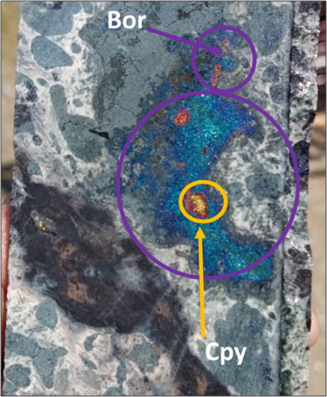
FIGURE 1: BORNITE PATCHES AND CHALCOPYRITE TRACES IN LHCC-23-004
Axo Copper Phase II Drill Program
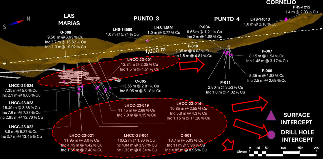
Axo has initiated its Phase II drilling program in which the Company plans to drill 15,000 metres. One drill rig is currently on site, with plans to target an area with a NE-SW strike length of approximately 1km, starting at Las Marias and stepping out to the north along strike towards the Cornelio target. The first hole is expected to be finished in approximately two weeks, with assays being released in the first half of July.
The first several holes are designed to intercept the La Huerta Trend at relatively shallow depths, within 100 metres from surface and stepping out sequentially to the north towards Punto 3 and Punto 4. While sequentially advancing drilling to the north, the company also expects to begin testing the system at depth, as mineralization has not been tested at depths below 200 metres from surface (Figure 2). Testing the depth potential below Las Marias is of particular interest to the Company, as the IP geophysics anomaly generated by Las Marias and the surrounding area increases with intensity at depth.
FIGURE 2: LONG SECTION FROM LAS MARIAS TO CORNELIO AND PLANNED DRILLING WITH SELECT DRILLHOLES HIGHLIGHTED (PLANNED DRILLING AREAS IN RED)
Overview of the La Huerta Project
The La Huerta Copper Project is in the south of Jalisco state in Mexico, and consists of two concessions which total 11,331 hectares. The site was recently active with artisanal mining up until 2022, when Axo acquired rights to the project. Mining took place from surface, with mineralized rock trucked ~30 miles away from La Huerta to a nearby processing facility.
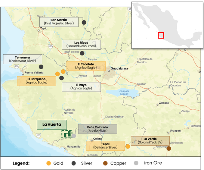
FIGURE 3: LOCATION OF LA HUERTA COPPER PROJECT IN JALISCO, MEXICO
The Las Marias Zone is characterized by copper sulphides, with mineralization hosted in chalcopyrite and bornite (Figure 1), extending to surface. Figure 4 below shows past sampling results from the historical Las Marias pit, which included 3.2 metres grading 21.4% copper, and 9.4 metres grading 4.4% copper. The zone itself lies on the southwest end of the broader La Huerta Trend, characterized by a 5km+ strike length as evidenced by copper samples at surface (see Figure 5 below).
FIGURE 4: HIGH GRADE SAMPLING WITHIN THE LAS MARIAS PIT
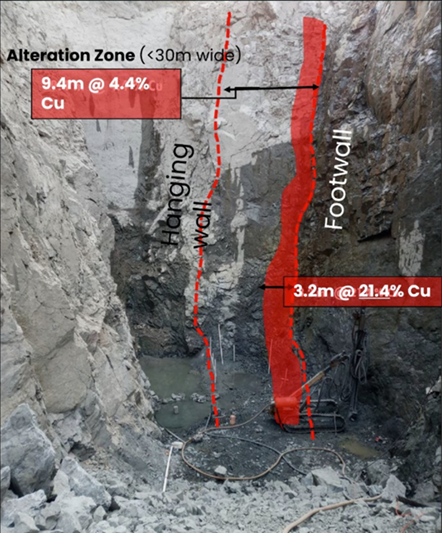
FIGURE 5: LAS MARIAS AS PART OF A BROADER 5KM TREND
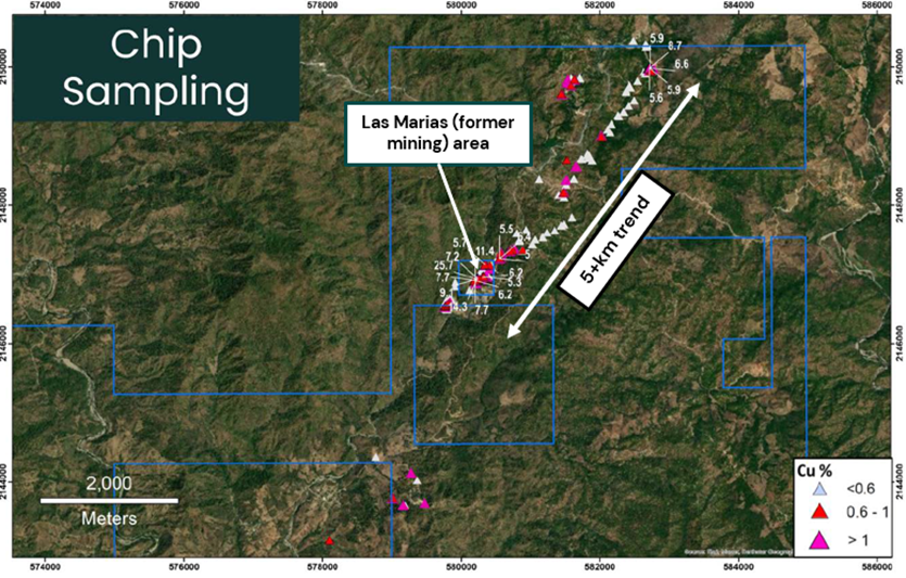
Table 3: Drill Hole Locations (UTM WGS84 13 Zone)
Hole ID | ||||||
EASTING | NORTHING | ELEV | DEPTH | AZ | DIP | |
m | m | m | m | ° | ° | |
C-001 | 580310 | 2146823 | 674.6 | 195.6 | 3.3 | -49 |
C-005 | 580339 | 2146877 | 680.0 | 137.1 | 2.5 | -58 |
G-008 | 580218 | 2146876 | 640.0 | 76.0 | 330.0 | -65 |
LHCC-23-001 | 580310 | 2146827 | 674.5 | 177.0 | 3.3 | -49 |
LHCC-23-004 | 580264 | 2146885 | 649.1 | 150.0 | 330.0 | -68 |
LHCC-23-014 | 580323 | 2146860 | 672.8 | 168.0 | 4.0 | -53 |
LHCC-23-019 |